

Monitoring two areas in the Atlantic for tropical development, including the Southeast Coast
The National Hurricane Center is watching an area where a tropical system could impact North Carolina
Start with the beach forecast first though, looking down at Myrtle Beach, Bar Harbor Resort Camps.com, Tide’s out at the moment. High tide later on this evening, around 11 o’clock for high tide for them, and Saturday looks like the best of the days coming up over the weekend for the beaches, *** better chance for showers and storms with impact days along the Outer Banks and down towards Atlantic Beach and Morehead City on Sunday. Uh, and then *** chance for scattered showers and storms down along Wrightsville and Myrtle Beach on Sunday afternoon too. Uh, tracking the tropics, we’re watching. Uh, one little area here that may develop over northeastern parts of the Gulf as we go through the next few days, slow developments possible, uh, as it will drift off to the north *** little bit more, already bringing some heavy rains to the Florida coast up around areas of uh Gainesville, Cedar Key picking up some heavy showers and storms. Now I know you see the satellite imagery and you’re saying, wow, look at that big spin. This is actually in the mid and upper levels of the atmosphere. This is an upper low that’s spinning. There is *** surface trough out here and that’s where this, uh. may develop as we go into the next 3, maybe 4 days or so. The other place we’re watching is over just off the coast of Africa. This little area just south of the Cape Verde Island right now, Cabo Verde, um, that may develop as we go into the weekend, but if it does, it’s going to go into some winds. They’re *** little less favorable for it to develop anymore, so I don’t expect it to do *** whole lot as it pushes on off to the west northwest as we go into the next couple of days. Air quality is in the code orange. 8 o’clock tonight for unhealthy sensitive groups out there, they’re very young, older folks or people that may have respiratory, uh, or heart issues out there, you may want to limit your time even, uh, as the sun goes down *** little bit, *** little while longer for the day. Uh, we’ve also had some smoke, some light smoke across the area from those Canadian wildfires as we go on into the day tomorrow. *** lot of that should recede off to the northeast, um, where areas right now where there’s *** lot of smoke up around Philadelphia tomorrow will inundate. Areas of, uh, Cape Cod, Boston, up around parts of Maine, and also staying in place over areas of the northern Great Lakes. UP of Michigan still has some heavy smoke up in some of those areas, causing them some issues and respiratory issues in *** pretty bad way up there as well. 98 right now in Burlington. It’s hot out. 93 in Greensboro, 95 in Lexington at this hour. Heat index team in the humidity, it feels like it’s 100 in Burlington, 102 Lexington, and right around 100 just about everywhere from the foot. Hills all the way down here to the Piedmont. High temperatures today got to 95 officially at the airport in Greensboro, 98 in Burlington, and 91 in Wilkesboro. So even the elevation out west has, uh, kept their temperatures hot too. And tomorrow will be another day we’ll see temperatures between 100 to 103 across the Piedmont. No heat advisory out, but it’s still going to be hot and humid out there. We are in this moderate to major risk for heat related illnesses. If you’re out tomorrow for an extended period. Time, so you need to take some breaks inside. We’ve had *** couple of showers and thunderstorms trying to develop this afternoon. One just over northern parts, northeastern parts of Randolph County, also into Rockingham County, and *** little thunderstorm cell that’s just along the Stokes Surry County line over southern parts of those areas. We’ll watch those. They have had some heavy rains with them tomorrow and Sunday. We are in the slight to marginal risk for the triad gets bisected, uh, through the day tomorrow with, uh, eastern parts of. The triad down to the east and this level 2 slight risk for the chance for severe thunderstorms tomorrow, damaging winds, *** high probability, and some localized flooding too. So be mindful of that in the afternoon and evening tomorrow and for Sunday as well. High temperatures tomorrow will be into the low and mid 90s. You might have to fight *** scattered shower or thunderstorm on Sunday, uh, up over areas of Wilkesboro for the race on Sunday. So be mindful of that too. Scattered showers and storms in for early next week. Highs in the low 90s.
Start with the beach forecast first though, looking down at Myrtle Beach, Bar Harbor Resort Camps.com, Tide’s out at the moment. High tide later on this evening, around 11 o’clock for high tide for them, and Saturday looks like the best of the days coming up over the weekend for the beaches, *** better chance for showers and storms with impact days along the Outer Banks and down towards Atlantic Beach and Morehead City on Sunday. Uh, and then *** chance for scattered showers and storms down along Wrightsville and Myrtle Beach on Sunday afternoon too. Uh, tracking the tropics, we’re watching. Uh, one little area here that may develop over northeastern parts of the Gulf as we go through the next few days, slow developments possible, uh, as it will drift off to the north *** little bit more, already bringing some heavy rains to the Florida coast up around areas of uh Gainesville, Cedar Key picking up some heavy showers and storms. Now I know you see the satellite imagery and you’re saying, wow, look at that big spin. This is actually in the mid and upper levels of the atmosphere. This is an upper low that’s spinning. There is *** surface trough out here and that’s where this, uh. may develop as we go into the next 3, maybe 4 days or so. The other place we’re watching is over just off the coast of Africa. This little area just south of the Cape Verde Island right now, Cabo Verde, um, that may develop as we go into the weekend, but if it does, it’s going to go into some winds. They’re *** little less favorable for it to develop anymore, so I don’t expect it to do *** whole lot as it pushes on off to the west northwest as we go into the next couple of days. Air quality is in the code orange. 8 o’clock tonight for unhealthy sensitive groups out there, they’re very young, older folks or people that may have respiratory, uh, or heart issues out there, you may want to limit your time even, uh, as the sun goes down *** little bit, *** little while longer for the day. Uh, we’ve also had some smoke, some light smoke across the area from those Canadian wildfires as we go on into the day tomorrow. *** lot of that should recede off to the northeast, um, where areas right now where there’s *** lot of smoke up around Philadelphia tomorrow will inundate. Areas of, uh, Cape Cod, Boston, up around parts of Maine, and also staying in place over areas of the northern Great Lakes. UP of Michigan still has some heavy smoke up in some of those areas, causing them some issues and respiratory issues in *** pretty bad way up there as well. 98 right now in Burlington. It’s hot out. 93 in Greensboro, 95 in Lexington at this hour. Heat index team in the humidity, it feels like it’s 100 in Burlington, 102 Lexington, and right around 100 just about everywhere from the foot. Hills all the way down here to the Piedmont. High temperatures today got to 95 officially at the airport in Greensboro, 98 in Burlington, and 91 in Wilkesboro. So even the elevation out west has, uh, kept their temperatures hot too. And tomorrow will be another day we’ll see temperatures between 100 to 103 across the Piedmont. No heat advisory out, but it’s still going to be hot and humid out there. We are in this moderate to major risk for heat related illnesses. If you’re out tomorrow for an extended period. Time, so you need to take some breaks inside. We’ve had *** couple of showers and thunderstorms trying to develop this afternoon. One just over northern parts, northeastern parts of Randolph County, also into Rockingham County, and *** little thunderstorm cell that’s just along the Stokes Surry County line over southern parts of those areas. We’ll watch those. They have had some heavy rains with them tomorrow and Sunday. We are in the slight to marginal risk for the triad gets bisected, uh, through the day tomorrow with, uh, eastern parts of. The triad down to the east and this level 2 slight risk for the chance for severe thunderstorms tomorrow, damaging winds, *** high probability, and some localized flooding too. So be mindful of that in the afternoon and evening tomorrow and for Sunday as well. High temperatures tomorrow will be into the low and mid 90s. You might have to fight *** scattered shower or thunderstorm on Sunday, uh, up over areas of Wilkesboro for the race on Sunday. So be mindful of that too. Scattered showers and storms in for early next week. Highs in the low 90s.
Updated: 6:33 PM EDT Jul 17, 2026
Editorial Standards ⓘ
Monitoring two areas in the Atlantic for tropical development, including the Southeast Coast
The National Hurricane Center is watching an area where a tropical system could impact North Carolina
The tropical Atlantic has been very quiet for nearly a month. There has been little to no activity since Tropical Storm Arthur formed in the Gulf in mid-June. This week, National Hurricane Center (NHC) meteorologists have flagged two tropical areas of interest, and one is very close to home.
Tropical development possible off the East Coast
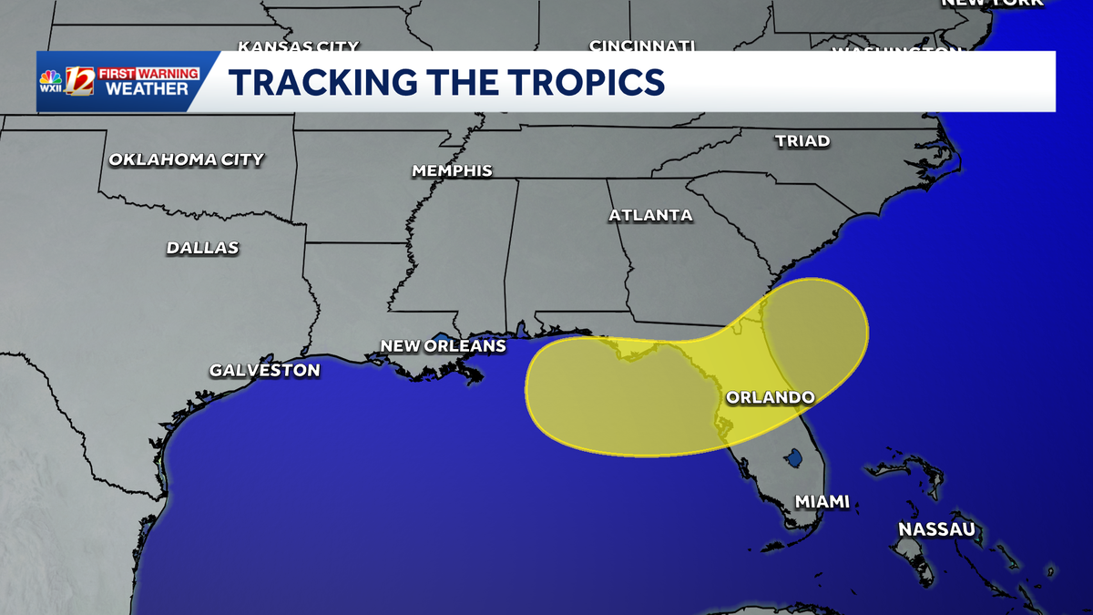
Over the weekend, an area of low pressure may form in the northern Gulf, near the Big Bend region of Florida. The potential low is expected to track northeast across the Sunshine State and then over the warm Gulf Stream along the Southeast U.S. Coast. Beachgoers from Florida, Georgia, South Carolina, and North Carolina may begin to experience heavy clouds, frequent rain and storms, with bigger waves at the beginning of next week.
This content is imported from Twitter.
You may be able to find the same content in another format, or you may be able to find more information, at their web site.
This slow-moving system may develop tropical characteristics once it returns to the warm Atlantic waters along Florida’s eastern seashore. However, the odds are against the disturbance becoming a tropical system. The WXII 12 First Warning Weather Team recommends that you monitor the tropics closely if you have a beach trip planned for next week.
Tropical development possible in the eastern Atlantic
The second area of tropical interest is a tropical wave that moved off the west coast of Senegal and Guinea-Bissau on Wednesday. The disturbance is now southeast of Cabo Verde and moving west-northwest. The tropical wave has a low chance of developing into a tropical depression this week before it moves into a harsh environment this weekend. It currently has a 10% chance to develop into a tropical depression this week.
Find the latest tropical details from the NHC here and on the WXII 12 First Warning Weather Interactive Radar here by using the tropicallayers located at the bottom right of the radar image.
North Carolina Outer Banks forecast
Crystal Coast forecast
Southern beaches forecast
More weather stories
More weather coverage:Weather Alerts | Latest weather forecast | Post pictures to the uLocal North Carolina Facebook Group | Traffic information | Report closings and delays | SkyCams | Download the WXII12 News mobile app
Weather Information
‘
+ ‘
‘;
var gptLayer = window.gptLayer;
if (gptLayer && typeof gptLayer.insertAds === ‘function’) {
var slotsBefore = gptLayer.adSlots ? gptLayer.adSlots.length : 0;
gptLayer.insertAds();
if ((gptLayer.adSlots ? gptLayer.adSlots.length : 0) > slotsBefore) {
if (typeof gptLayer.callAdSlots === ‘function’) {
gptLayer.callAdSlots(‘imm’);
}
}
}
}
}
function closeRadarOverlay(containerId) {
var overlay = document.getElementById(containerId + ‘-radar-overlay’);
if (!overlay) return;
overlay.classList.remove(‘is-open’);
overlay.setAttribute(‘aria-hidden’, ‘true’);
document.body.classList.remove(‘weather-radar-overlay-active’);
var adSlot = overlay.querySelector(‘.weather-radar-overlay__ad-slot’);
if (adSlot) {
adSlot.innerHTML = ”;
}
}
function trackRadarOverlayInteraction(containerId) {
var now = Date.now();
var key = ‘radar_overlay_last_interaction_’ + containerId;
if (!window[key] || now – window[key] > 10000) {
window[key] = now;
dispatchWeatherGA4Event(‘radar_overlayinteraction’, ‘interaction’, containerId);
}
}
function isMobileOrTabletViewport(breakpoint = 980) {
const w = window.innerWidth || document.documentElement.clientWidth || 0;
return w
